
Monday, May 6, 2013
Tuesday, April 30, 2013
Start of Draft

Sunday, April 28, 2013
Topographic Map

My client Nick Conrad sent me the tax parcels for Rensselear county and I was able to input that into the map. Also I was able to add a topographic base map that shows the elevation in this area.
Tuesday, April 9, 2013
Goals For This Week
This week I hope to obtain an official boundary or a tax parcel data from Rensselear County. Also I would like to mark where the trail is with lines as well as contact my client to see how he wants the final map to be presented. I am also going to look at past projects that people have done in order to get some ideas on what else should be incorporated into my map. I am also going to check ArcGis online in order to find some other data layers that could be beneficial to this map. For example topography lines need to be added in order to show the elevation change while walking among the preserve.
Tuesday, April 2, 2013

Collecting GPS Data Points
On Friday March 23 I visited the preserve and took GPS data points. I along with Nick Conrad and 2 of his fellow land trust members had to use snowshoes in order to hike in and reach the preserve. We hiked in through the woods for a little until we came to a snowmobile trail which ran in to the old turnpike road. We then took that road which lead us right into the preserve. On our hike we visited the 2 vernal pools that are located on the preserve as well as the highest point on the preserve. We followed trail markers but by making this map I hope to make it easier to follow the trail to the Vernal pools. I took GPS points along the trail and at the Vernal Pools that we stopped at. Also there was a stone wall that we found and I marked the coordinates of it as well. It was a great day for snowshoeing and I had a lot of fun visiting this preserve.
Tuesday, March 19, 2013
Wetlands

Wednesday, March 13, 2013
Progress
I was able to finds some data layers that i hope will be helpful to my project. These data layers include wetlands, streams, and elevation. I hope to go out and visit my preserve soon so i can start to import the data i gather while I am out there.
Thursday, February 28, 2013
Project Proposal
Matt Porter
Project proposal
Geiser Preserver
Introduction:
The Rensselaer land trust has acquired some land and it is called Geiser Preserve It is home for a wide variety of plant species in Rensselear. This land has not been used and it has not been completely explored yet. My job will be to see what is on this land and mark them on a map that will be available for the public. It is a 95 acre preserve and it has an elevation range from 1600-1900 feet. Geiser preserve is located high up on the Rensselear Plateau.
Methods:
The methods used in order to obtain data will be through GPS, ArcGIS, and visiting the actual swamp. I will map the trail and the locations of the rare vegetation with the GPS and I will be able to import them into ArcGIS. I will put the GPS points into an excel file and then I can add them in to the ArcGIS data layer. A meeting has been set for next week and we will go over the site and what the client expects from me. Things that will be mapped would be streams, trails, and places for the public to enter into the preserve. To map some of these elements I will start by making a base map and then add data layers like the wetland and streams. I will then zoom into the area of Geiser Preserve and I will be able to tell what features are located here. The data layers mention above have already been gathered and placed in the course projects folder. Data layers will be obtained from ArcGIS online as well as Mr. Conrad if he has any that I cannot find.
Objectives:
Some of the major tasks will be going out into the field and gathering data points. Also a rough map will have to be created and showed to the client in order to be critiqued. I plan on mapping features like streams wetlands and places that will be of interest to the public. I plan on doing some work on the map the week of the 18th before I go out to the location with my client. The next week is break and when I get back to school I hope to start importing some of the data that I gathered over break. After that I hope to work on it a little during each week and meet with my client to see what he thinks. I hope to have the map done by mid late April if all goes as planned.
3/5 Meeting with Client to discuss the preserve.
3/12
3/19 set up meeting in order to meet at the preserve.
3/23 meet with the client at the preserve in order for me to get familiar with it.
Week of the 3/24 return to the preserve to gather mare data that is necessary for the map.
4/2 start importing the data into ArcGIS.
4/9 continue to work on map during the week
4/16 create a rough draft to show client and my professor
4/23 make correction to the map and finalizes it
5/3 have map complete
Deliverables:
The map will be printed in black and white on a regular sheet or printer paper so people can take with them on the trail with them. Also the data layers will be sent to the RLT so they can use them as well as make modifications as time progresses.
Geiser Preserve
 |  |
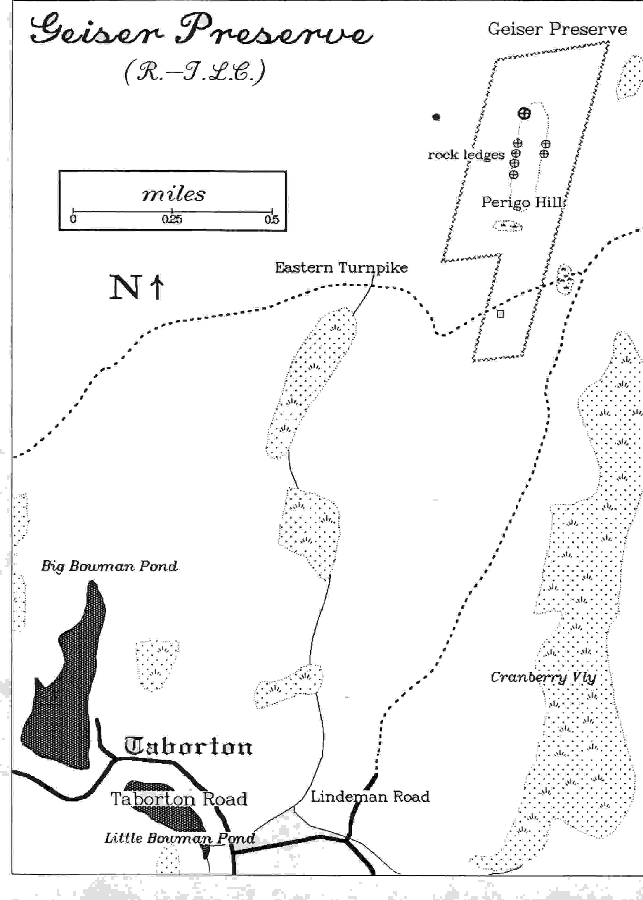
The Geiser Preserve is beautiful woodland of 95 acres, high on the Rensselaer Plateau. The access route
follows a level dirt road (Lindeman Road) through attractive woods. The preserve has only one trail, a short section of the old Eastern Turnpike of 1802. Elevations here range from 1600 to 1900 feet. The forest consists of sugar maple, American beech, and eastern hemlock. The understory is full of witch hobble, striped maple, and an incredible carpet of ferns. Fern gathering for florists was one of the sources of income for Plateau residents years ago. There are small wetlands and rocky knolls within the preserve. There are a number of seasonal flowers. Jack-in-the-pulpit and many violets are found in the spring, and asters, white snakeroot, and goldenrods in the late summer and fall. Ferns include royal, interrupted, lady, wood, marginal shield, Christmas, maidenhair, hay-scented, bracken, and grape. From the highest elevation on the former Turnpike, in the preserve, you can bushwhack to the north, following the height of land and reach the summit of Perigo Hill. It is a rocky ascent, and difficult to see your footfalls in the abundance of ferns. In late fall and winter the view is well worth the effort. If you bushwhack, take along a compass. The Conservancy has plans to mark trails through the area in the future. The roads are good for cross-country skiing. The preserve was a gift of Ruth Nevin, a former Taborton teacher, who purchased the land in 1932. She remembers school picnics there when the land was open and the views superb. The name "Geiser" was chosen in memory of her parents. In the past, gathering of ferns and club mosses for holiday greens was a substantial cottage industry in this part of the County.
Permission of the RLT is required for access.
Property owned by the RLT.
|
Subscribe to:
Posts (Atom)